Carnival event maps
Use our main interactive Carnival event map to visualise the route and facilities provided for this iconic event.
or alternatively, link to the same Carnival map.
'What is near me' app
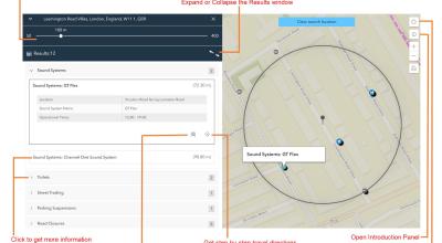
Use our What is near me app to find information and directions to nearby facilities and services within the Carnival area. To search:
- Desktop
input a postcode or address in the search bar. - Mobile device
the app will use your current location (ensure you have your location enabled), or you can input a street or postcode into the search bar
Finally, the following collection of maps are available here and on associated pages in our Carnival Hub. Each map focuses on specific information/activities related to the Carnival.
- Parade route
-
Shows the Parade route, where costumes and mobile sound systems meet spectators, and the Judging Zone, where parade bands get marked by distinguished judges.
- Sound systems
-
Eclectic sound styles from legendary to the up and coming.
- Street trading
-
Many stalls offering delicious food, drink and Carnival accessories.
- First Aid centres
-
Several first aid centres are provided by St John Ambulance, the nation’s leading first aid charity.
- Toilets
-
Numerous toilet points across the Carnival area.
- Road closures and parking restrictions
-
Roads are closed to Carnival visitors to help with crowd and emergency vehicle management.
- Restricted pedestrian access
-
Several roads across the Carnival event area will be closed to the public to help with crowd management or to host event support infrastructure. These roads will be cordoned off with staffed barriers.